Great Lakes Basin Railroad


Great Lakes Basin Transportation’s clean sheet approach to its proposed route takes into account the location of towns, residential areas, greenfield territory, and the locations where interchanges with other railroads will work after considering other potential alternatives.
A major design precept is to avoid building the railroad through densely populated areas. The route choice as presented considers our design precepts and environmental factors from the standpoint of making the least impact to the region while meeting the future needs of logistics in the United States. The route is designed to avoid major population centers. Great Lakes Basin Transportation has and will continue to work with the Surface Transportation Board’s Office of Environmental Analysis, which will oversee the Environmental Impact Statement for the project.
In addition to 21 potential railroad connections and points of intersection with 6 interstate highways, Great Lakes Basin Railroad route will also involve three significant river crossings, all in the State of Illinois: Fox River in LaSalle County; Illinois River in Grundy County; and Kankakee River in Kankakee County. The precise location, design and appearance of these bridges will depend on several factors, including environmental conditions.
OUR ROUTE
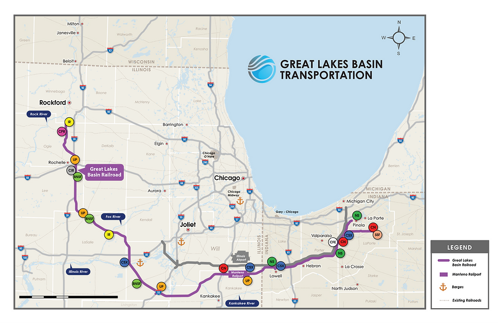
The Great Lakes Basin Railroad is a new freight railroad line around the metropolitan Chicago area. The purpose of the railroad is to improve safety, capacity, velocity, reliability, revenue, and the environment for expediting rail shipments around the Chicago rail hub and meeting the needs for future traffic growth. Great Lakes Basin Railroad proposed rail line starts in northern Indiana, west of Pinola, IN at a junction with the Norfolk Southern headed south/southwest going east of Westville, IN, east of Valparaiso, IN, west of Wanatah, and South Wanatah, IN, north and west of Hebron, IN, crossing over Interstate 65, and north of Lowell, IN. Crossing into Illinois going west towards Manteno,IL, crossing over Interstate 57, going west then southwest to cross the Kanakakee River, then turn west towards Gardner, IL to cross Interstate 55, turning northwest to cross the Illinois River east of Seneca, IL. The railroad then turns north/northwest, crossing over Interstate 80, crossing the Fox River near Sheridan, IL and northwest around Paw Paw, IL, it continues north to a point east of Rochelle, IL, where it crosses over Interstate 88, and then northwest crossing over Interstate 39, turning north to connections with Canadian Pacific and the Illinois Railroad south of Rockford, IL.
The railroad will have two branch lines with one called the Kingsbury Subdivision starting with an interchange point in Kingsbury, IN with South Shore Freight and continuing on to connect with the mainline around Westville, IN. The second branch is the CORR Subdivision, a short connection with the City of Rochelle Railroad on the southeast side of Rochelle, IL where it will cross over Interstate 39.